

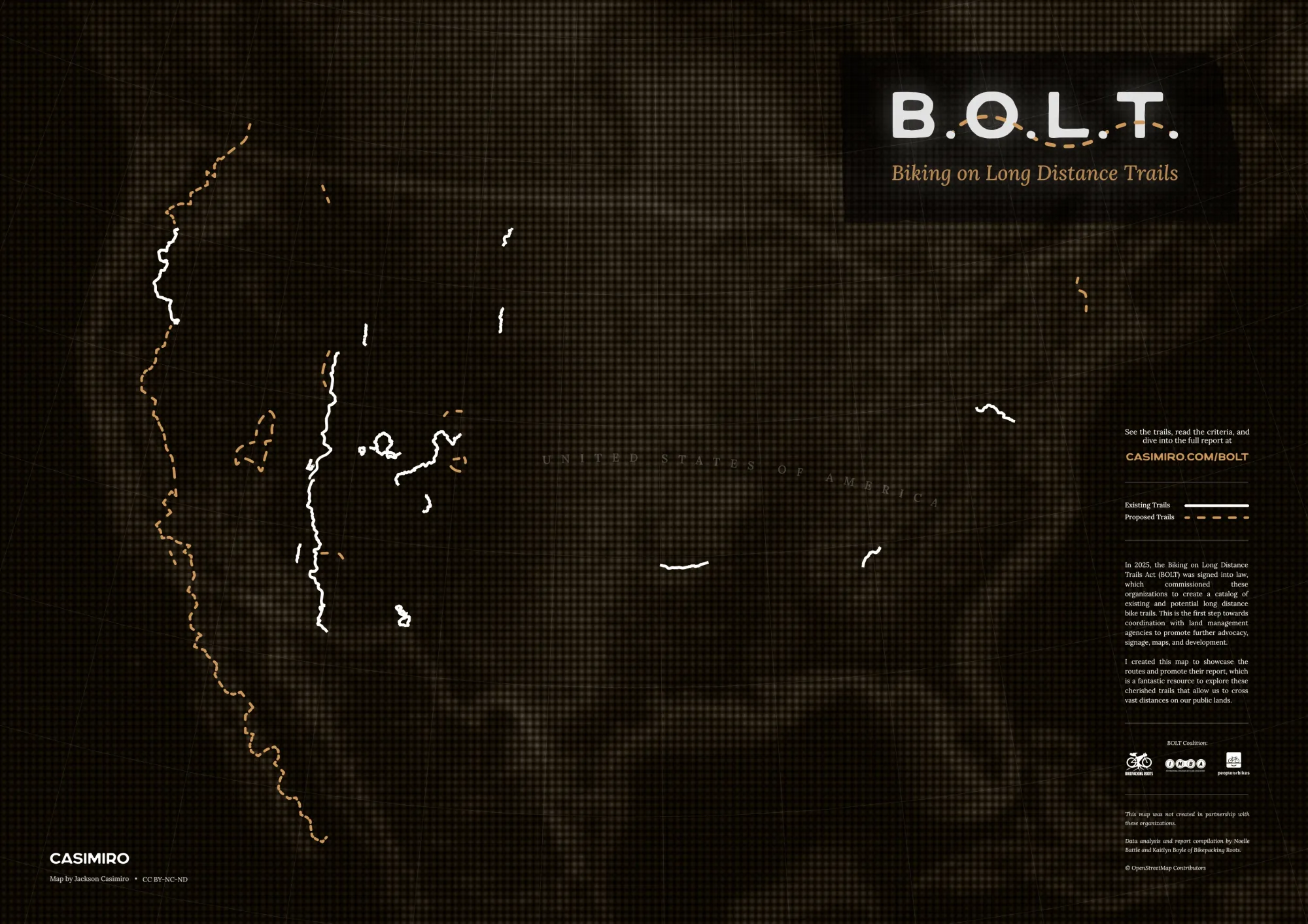
The Off-Road Bike Interstate is Growing
The BOLT Coalition published its report on our nation's existing and potential long-distance bike routes. I mapped them.


We Americans are spoiled with rich and vast public lands, where generations of trail builders have carved thousands of miles of singletrack and roads. As our lives and highways have only gotten busier, these trails have offered cyclists a much-needed respite. You can stitch these networks together into epic bikepacking routes, but the longer your journey, the more valuable good information becomes.
In 2025, the Biking on Long Distance Trails Act (BOLT) was signed into law as a part of the EXPLORE Act. Its goal was to recognize and advocate for long-distance bike trails. It commissioned a coalition of organizations to create a catalog of existing and potential routes—no less than 80 miles, primarily through public land, and on natural surfaces. This would be the first step towards coordination with land management agencies to promote further development.
This summer the coalition released the report, titled "Long Live Long Trails." It overdelivered with an extensive collection of validated trails and honorable mentions. Every route is described and cataloged with elevation profiles, photography, and more resources. It's a fantastic compendium to explore these cherished trails.
This project is intrinsically connected to one of my favorite things, information design—maps and signage. I truly believe good info design is key to responsible and enjoyable outdoor access. Especially for proposed routes, maps are a vital tool for imagining the potential. Look at Orogenesis who does a stellar job selling the vision for their ambitious continental crossing.
I created this map to showcase the BOLT routes and promote the report. I wasn't able to get the precise data in every case, but it's a decent representation. I created it from scratch in QGIS and Affinity. It's released under CC BY-NC-ND 4.0, so feel free to download and share. Apologies to Alaska.
My sincere thanks to the organizations (Bikepacking Roots, IMBA, and PeopleForBikes), as well as the authors and designers Noelle Battle, Kaitlyn Boyle, Cameron Sanders, and Shannon Villegas.
Below I've included tables with the trails and their criteria for inclusion, taken from the report. I've edited slightly for brevity. But absolutely check out the full document and get involved with your local stewardship organizations.
Existing Trails
Existing Long Distance Bike Trail means a continuous route, consisting of 1 or more trails or rights-of-way that fits the following criteria.
- There is a total, current existing, contiguous trail distance of at least 80 miles
- The majority of the trail is on Federal recreational lands and waters ( ie. Forest Service, Bureau of Land Management, National Park Service, etc)
- Are primarily dirt/natural surface (short connectors on pavement/improved roads are acceptable)
- Are composed of generally consistent types of trail (i.e., primarily singletrack, or primarily 4x4 roads)
- May be legally used for mountain biking, road biking, touring, or gravel biking
- The trail exists as a “known entity” not just a combination of shorter existing trails that equals over 80 miles.
- There are resources in the public domain for cyclists or other trail users to be able to navigate the contiguous trail.
| Trail Name | State(s) | Distance (mi) | Federal Agency |
|---|---|---|---|
| Arizona National Scenic Trail | Arizona | 834 | USFS, BLM, NPS |
| Black Canyon National Recreation Trail | Arizona | 97 | BLM, USFS |
| C&O Canal Trail | Maryland/DC | 185 | NPS |
| Carson Continental Divide Epic | Colorado/New Mexico | 92 | USFS |
| Centennial Trail | South Dakota | 111 | USFS, BLM, NPS |
| Colorado Trail | Colorado | 540 | USFS, BLM |
| Grandview Trail #33066 | Utah | 83 | USFS |
| The Grand Loop | Colorado/Utah | 365 | USFS, BLM |
| Great Western Trail (UT Section) | Utah | 673 | USFS, BLM |
| Kenai Mountain Bike Trail | Alaska | 234 | USFS |
| Kokopelli Trail | Colorado/Utah | 142 | BLM |
| Maah Daah Hey | North Dakota | 158 | USFS, NPS |
| Monumental Loop | New Mexico | 250 | BLM |
| Oregon Timber Trail (OTT) | Oregon | 684 | USFS |
| Ouachita National Recreation Trail | Arkansas | 108 | USFS |
| Paradox Trail | Colorado | 120 | USFS, BLM |
| Pinhoti Trail - Georgia Section | Georgia | 128 | USFS |
| Tabeguache Trail | Colorado | 142 | BLM, USFS |
| White Rim | Utah | 100 | NPS, BLM |
| Wyoming Range National Recreation Trail | Wyoming | 80 | USFS |

Potential Trails
Potential Long Distance Bike Trails are trails that fit the criteria above, and although they are not currently contiguous for at least 80 miles or do not yet have published resources, they have the potential for development into a trail of this scale. They also fit the following criteria in terms of completion:
- At least 40 miles of the envisioned trail is already existing (does not have to be contiguous)
- At least 50% of the total trail distance is complete (for example, there is potential for a 90 mile trail with 50 miles complete - ie 55% complete)
- Trails have a vision and at least a potential path forward for completion
The coalition also considered some other criteria that were deemed important for the sustainability of long-distance trails and the dedication of resources to them. These include:
- The trail is supported and/or stewarded by a local or regional trail organization (or coalition thereof) or through other organized community support, and relationships exist with relevant land managers.
- The trail would benefit from the recognition as a Long-distance Bike Trail for maintenance, access, promotion, or other benefits.
- The current and potential economic impact of the trail on surrounding communities.
- If the trail is a loop, the loop should connect distant towns or trail networks, and not be a loop within a single trail network.
| Trail Name | State(s) | Total Distance Currently (mi) | Total Distance When Complete (mi) | Federal Agency |
|---|---|---|---|---|
| Alpine #7 | Montana | 75 | USFS | |
| Bonneville Shoreline Trail | Utah | 100 | 280 | USFS |
| Chugach Mountain Bike Trail | Alaska | 200 | 325 | USFS, BLM, DoD (Fort Richardson) |
| East Side Sierra Towns to Trails | California | 355 | USFS, BLM | |
| Great Basin Trail | Nevada | 657 | 657 | BLM, USFS |
| Highline National Recreation Trail | Arizona | 67 | 82 | USFS |
| Orogenesis | Washington, Oregon, Nevada, California | ~3,500 | ~3,500 | USFS, BLM |
| Ring the Peak Trail | Colorado | 63 | 87 | USFS |
| Santa Ana Mountains Traverse | California | 85 | 85 | USFS |
| Southern Trek Iditarod Trail | Alaska | 84 | 107 | USFS |
| Tour de Poudre | Colorado | 90 | 90 | USFS |
| Velomont Trail | Vermont | 86 | 485 | USFS |
| Verde Valley Circle Trail | Arizona | ~70 | 150 | USFS |


Discussion